Mars Reconnaissance Orbiter
|
Mars Reconnaissance Orbiter |
The People's Camera An incredible camera sits atop an Atlas V rocket on the launch pad at Kennedy Space Center waiting to embark on a seven month journey to Mars. Many cameras have been sent to Mars over the past five decades and several are still imaging the Red Planet today. HiRISE is the latest in a series of evolving instruments. It will give scientists very high resolution images of Mars. According to Alfred McEwen, HiRISE Principal Investigator, "to see all of a HiRISE image in full-resolution, you would need twelve-hundred of your typical computer monitors stacked up." HiRISE, a very high-quality instrument supplied by Ball Aerospace, is basically a very large digital camera and will be the largest camera ever to leave Earth orbit. Also a large telescope, it has a primary mirror that is half a meter in diameter. The back of this telescope has a focal plane system. There are a total of 14 CCD detectors, so this is like 14 cameras flying in a close array. Ten cameras are black and white and the ones in the middle provide infrared color. The Mars Orbiter Camera (MOC) on Mars Global Surveyor arrived at Mars in 1997 and it has revolutionized our understanding of Mars. MOC continues to orbit Mars sending back incredible images but HiRISE will be about five times finer pixel scale.
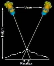
One of the main objectives of the HiRISE instrument is to measure the topography of Mars at a very high resolution. The whole spacecraft will be positioned to focus on points on the surface from two different orbits at two different angles. That is the same way we see stereo with our eyes. From these images, scientists can derive topographic models with meter-scale resolution. According to Dr. McEwen, "with such digital topography we can do quantitative modeling of processes such as groundwater flow, gully formation and viscous relaxation of topography that is when there is ice near the surface. We can also use the topographic data to determine the 3-dimensional structure of layered deposits. Scientists will be able to determine if a particular surface was created horizontally, such as sedimentary deposits in a lake, or if material was "draped" over preexisting topography, moved about by wind and dropped from the Martian sky. HiRISE will also give a much finer look at the polar layered deposits. Polar deposits are of a particular interest for understanding climate change on Mars. Called "The People's Camera", HiRISE will revolutionize what we know about Mars. The general public is encouraged to join scientists and participate in this exploration by assisting in HiRISE targeting and data analysis. To learn more about the objectives and philosophy of this collaboration, see: http://hirise.lpl.arizona.edu/public.html Follow the Mars Reconnaissance Orbiter mission as it travels to Mars at: http://mars.jpl.nasa.gov/ If you have any questions about Mars, Mars exploration and astronomy, send them to: Imagiverse - Ask The Expert [Editor's Note: The source for the information on this article was taken from the MRO pre-launch science briefing that ocurred on 8 August 2005.] - 11 August 2005 |
| Last Updated: 11 August 2005 |
| Home | Contact Us | Credits | Sitemap | © 2005 - Imagiverse Educational Consortium |