|
|

 Welcome to El Salvador
 ![]()
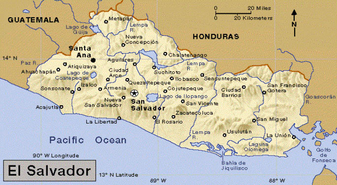
| Climate Tropical climate with pronounced wet and dry seasons; rainy season (winter) from May to October, dry season (summer) from November through April. Temperatures vary with elevation and show little seasonal change. Pacific lowlands uniformly hot; central plateau and mountain areas more moderate. Location El Salvador is located in the South-East part of the Central American isthmus, on the coast of the Pacific Ocean and it is unique in that it is the only country in that region that does not have shores on the Caribbean Sea. Geographical Position El Salvador lies on the Pacific Ocean coast of Central America, bordered by Guatemala and Honduras. It is north of the Equator, between 13°09 and 14°27 North latitude; and 87°41 and 90°08 West longitude. Topography Two parallel mountain ranges running east to west divide country into two regions: mountains and central plateau, and coastal plains (Pacific lowlands). Southern mountain range made up of more than twenty volcanoes. Eruptions rare, but earthquakes frequent because of location at conjunction of three geologic plates. Rio Lempa only navigable river. Numerous volcanic lakes in interior highlands. Important Cities Santa Ana: pop.
451,620 Form of Government El Salvador is a sovereign, republican and democratic representative country. The president is elected by the people for a period of 5 years and cannot be reelected. The Legislative Assembly is made up of 84 representatives. Food The typical food that identifies the Salvadorans around the world are the Pupusas. Pupusas come from the naguat word pupushahua that means tortilla filled with cheese, beans, chicharrón (pork), ayote, cream, carrots, etc. The tortillas are made of corn. Chilate con nuegados, shuco atole, tamales, etc. are also made from corn. Other products that tourists like are seafood (fish, shrimps, oysters , lobsters, etc.). Important Archeological Sites - Ruinas del Tazumal in the city of Chalchuapa, district of Santa Ana. - Ruinas de San Andres on the district of La Libertad. - Ruinas de Quelepa on the district of San Miguel. - Ruinas de Cihuatán, 41 kilometers North from San Salvador. - Ruinas de Tehuacán in San Vicente. - La Gruta de Corinto or Capilla Sixtina de los cacaoperas in Morazán. Schooling System School is mandatory from first grade to ninth grade (elementary and middle school). With three more years, one can receive a High School diploma. There are many private universities and the only public one is the Universidad Nacional de El Salvador. Map of El Salvador
Is the smallest Central American country in area. But it ranks as the third largest country in population in Central America. El Salvador is a tropical land of rugged mountains, cone-shaped volcanoes, green valleys, and scenic lakes. The Pacific Ocean lies to its south, Guatemala to its northwest, and Honduras to its northeast. Facts in Brief about El Salvador - Capital: San Salvador - Official Language: Spanish - Official name: República de El Salvador (Republic of El Salvador) - Area: 21,041 sq. km (8,124 sq. mi). Greatest distances-north-south- 142 km (88 mi); east-west, 262 km (163 mi). Coastline- 304 km (189 mi). - Elevation: Highest Montecristo, 7,933ft.(2,418m) above sea level. Lowest sea level along the coast. - Population: Estimated 2000 population 5,980,000; density, 284 per sq. km (736 persons per sq. mi); distribution, 50 percent rural, 50 percent urban. - Chief Products: Agriculture beans, coffee, corn, cotton, rice, sugar cane. Manufacturing chemicals, cigarettes, processed foods and beverages, leather goods, textiles. - Money: Basic unit Colón (¢). One hundred centavos equal one colon. Important Rivers: Rio Grande de
San Miguel Important Lakes: Lago de
Coatepeque Important Volcanoes: Volcán de Santa
Ana |
More information: |
||
| Explore More: Cities/Towns: |